New to Talea? Our Talea webinar is a great place to get started: There is a general overview provided by the video ‘Talea set-up and implementation of surveys; what and where to survey and basic analysis’, followed by case studies of Talea being used in the field with dog and cat surveys.
The Talea user guide should be your friend and guide through working with Talea. But if you find it is lacking in any way, or you have a question that is not answered in the user guide, please email us at talea@icam-coalition.org. Your feedback is extremely valuable to us, so don’t be shy!
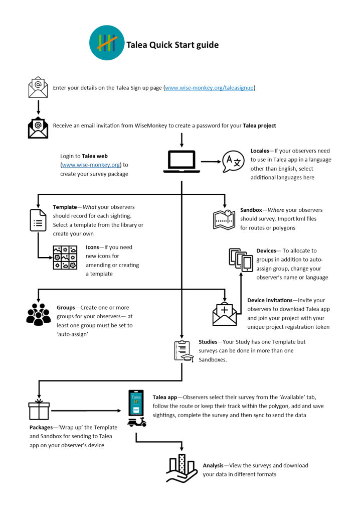
Please follow this link to our sign-up page which will automatically create your Talea project – section 2.1 in the user guide shows you how this first step works, including the follow-up email you will receive allowing you to create your password.
An introduction to Talea
Street surveys of roaming dogs and cats can be a quick way to gather data on their density, welfare and reproductive activity; and many other indicators besides. But if making sure you stay on the correct survey route, recording the same information about each animal and keeping your data safe is a challenge – then Talea is your solution. Talea app is avaiable for Android and iOS.
Talea is a street survey tool comprised of 2 parts:
- Talea web is where you design your survey and access your data
- Talea app is the mobile phone application that you use to record all the animals you see on your survey
Talea is designed to be simple:
- Recording sightings of animals and any number of characteristics relating to each animal.
- Using labelled icons in the app to minimise observer time when recording sightings with characteristics selected with a single tap.
- A background map supports navigation, including colour changes to indicate when observers have strayed ‘off route’, and the option to download map tiles so you can survey offline.
Talea is designed to be flexible:
- Working in Talea web, you can select a template from the library allowing for an ‘off the shelf’ survey or you can amend or create your own template.
- Although the working language for Talea web is English, you can select the Talea app language to suit individual observers.
- Sightings can be recorded with the GPS location of the observer at the time of recording or the observer can indicate on the map with a ‘dropped pin’ the exact position of the animal when it was seen.
- Observers can follow a survey route or work within a polygon that delimits the area to be surveyed.
This solution was developed in partnership with Wise Monkey Solutions, a US-based organisation with the mission to create software, systems, and technology to support NGO that strive for the sustainable health of people, animals, and the environment.
Click here to access the user guide for Talea web and Talea app
Click here to access ICAM’s guide to monitoring and evaluation ‘Are we making a difference?’; go to the chapter on ‘Street surveys‘ to learn more about this method of measuring indicators.


